|
Ride Report Ride: Washington State Challenge 1: Seattle-Windy Ridge (Mt. St. Helens)-Sunrise (Mt. Rainier)-Seattle Distance: 530 km (330 miles) Date: July 20-21, 2009 Time completed: 23:39 hours Riders: Ryan Hamilton, Jan Heine, Mark Vande Kamp Bicycles: LeMond Victoire (Michelin Pro2 Race 700C x 25 mm tires); Alex Singer Randonneur (Grand Bois Cyprès 700C x 30 mm tires); Curt Goodrich Randonneur (Mitsuboshi 650B x 38 mm tires), all with SON20 or SON20R generator hubs and LED headlights. Route: Seattle-Sumner-Orting-Eatonville-Elbe-Morton-Randle-Windy Ridge-Packwood-Cayuse Pass-Sunrise-Enumclaw-Kanasket-Renton-Seattle Click here for an approximate map of the course. (Click on "Terrain" for best view.) |
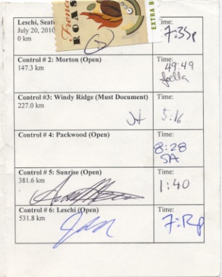
Our control card. |
The Original Challenge Part 1: Seattle-Packwood by Jan Heine Background The original idea for the Cyclos Montagnards Challenges came from reading about French constructeur Paul Charrel. Charrel lived in Lyon, and his goal was to ride from Lyon to the top of Mont Ventoux and back in 24 hours, a distance of 516 km, with the final climb being unpaved and on soft gravel. Charrel tried six times, but the powerful Mistral winds foiled every single one of his attempts. However, he completed other challenges, including riding from Lyon to the highest point at the foot of Mont Blanc. We liked the idea of a similar challenge linking our home town with our favorite mountain destinations. Windy Ridge on Mount St. Helens was an obvious choice, but the distance, out and back, of 450 km was not quite enough to fill 24 hours. What if we added Sunrise, the highest point on Mount Rainier? 530 hilly kilometers sounded about right for 24 hours. Thus, the original Cyclos Montagnards challenge was born. This was in the early spring of 2009, when many feet of snow covered our favorite mountain roads, and when our legs still lacked the shape for such an ambitious undertaking. Training and planning filled many enjoyable spring days. When a fellow randonneur, Geoff Swarts, reported that the high roads of Windy Ridge and Sunrise were passable, we realized it was time to try our challenge rather than continue training for it. Mark plotted an interesting route, combining familiar mountain roads with the shortest way in and out of Seattle. Our total distance would be just over 530 km. Ryan and Jan each drew up a time schedule for the ride, and surprisingly, until the last few kilometers, the schedules were nearly identical. Ryan predicted that if we rode well and carefully managed our stops we could finish the challenge with a comfortable margin of 11 minutes to spare. Jan's schedule finished 41 minutes earlier. Could we do it? Then, after dinner on a Tuesday evening, Jan rode to Mark's house, the two rode to Ryan's, and all of us entered the coffee shop in Leschi at 7:20 p.m. At 7:33, we had our cards signed and set off into the warm evening. |
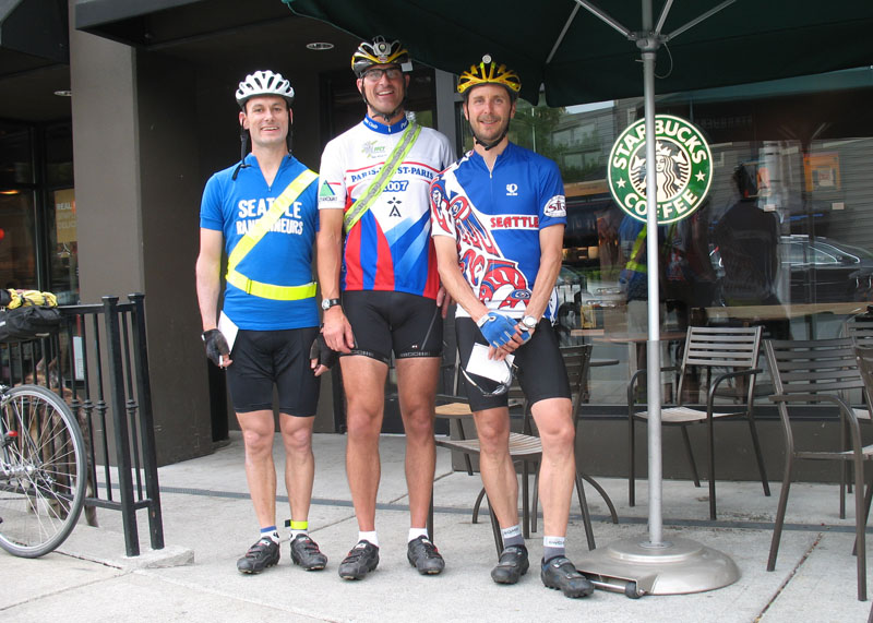
Click on image for large-resolution version.
Before the start in Leschi/Seattle. Left to right: Jan, Ryan, Mark. |
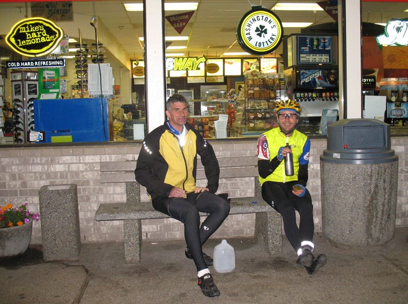
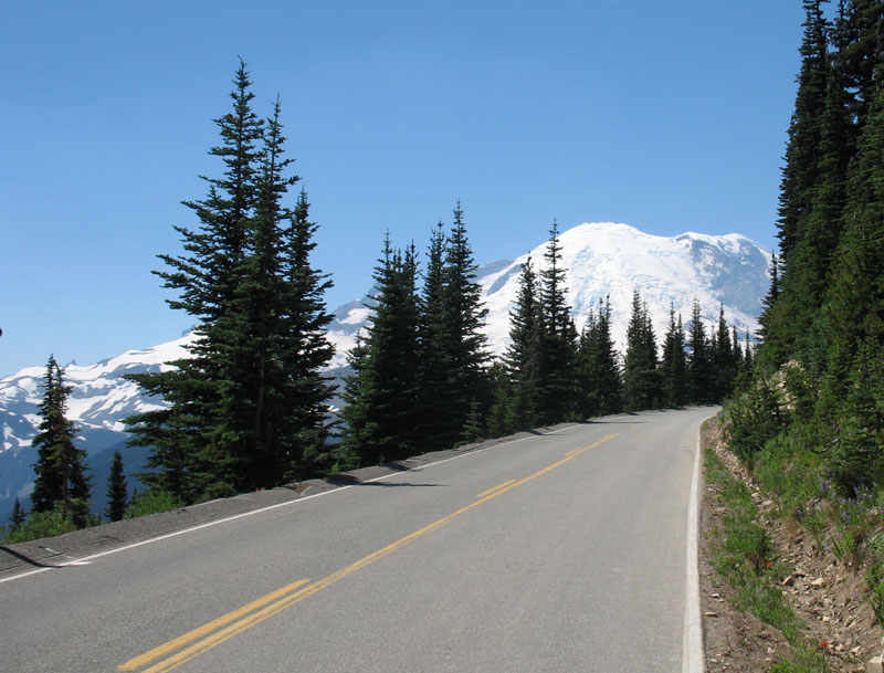
A light tailwind pushed us along Lake Washington in the sunny evening light. Mark and Ryan shared that they were a bit nervous about the undertaking, but these thoughts quickly faded as we slipped into our familiar pace line and headed for adventure. Our spirits were high, and even getting lost for a few minutes in a Renton office park in search of the Interurban Trail did not faze us much. Once found, the trail was less than ideal for quick progress. Every few hundred yards, a street crossing required stopping and yielding to cross traffic. It was a relief to get onto the backroads toward Sumner and on to Orting. The sun was setting beautifully on Mount Rainier in the distance, giving us a great view of our destination. Leaving Orting, we joined the roads that circle Mount Rainier, so familiar from many brevets and rides. It was a dark night without a moon, and there was no traffic. Had our modern LED headlights not been so bright, we could have enjoyed the stars while riding. Instead, we stopped and looked at the Milky Way, which was more clearly defined than usual at this low elevation. The night was warm, and our ride was off to a good start. The little traffic thinned to nothing as we turned at Kapowsin onto Orville Road. This road winds its way through a valley carved by an outlet of glacial lake Puyallup during the last glaciation. Like most glacial landscapes, the valley is not smooth, but dips and rises. Road building used to be an art as much as a science, and the builders of Orville Road long ago created a masterpiece. The road has a beautiful rhythm perfectly suited to our quick randonneuring pace. Each rise required just a slight increase of power output, sometimes a quick downshift, and the next dip enabled us to build momentum again. In the dark, we focused on the road even more than usual, and the roughly 15 kilometers flew by before we knew it. We reached Eatonville elated and 30 minutes ahead of schedule. Ryan requested an unscheduled water stop at a gas station, but Eatonville was closed at 10:30 p.m., so we continued without delay. Alder Cutoff Road may have been designed by the same engineers as Orville Road, as it has a similar flow. The rises got longer as we rode into the foothills of Mount Rainier, but this road, too, vanished almost too quickly below our wheels. By comparison, the modern highway to Elbe seemed to stretch interminably. Only the occasional remnants of glass bottles on the wide shoulder broke the monotony. We passed the old trains of the railroad museum, then turned off into the hills again to reach Morton just before one o'clock. Our quick food and water stop at a gas station made us realize that the warm night has turned cooler, and Jan shivered until the next hill warmed him up again. |
Our first stop in Morton, past midnight. |
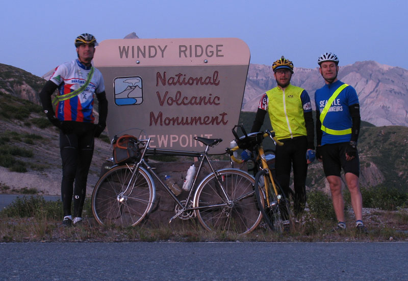
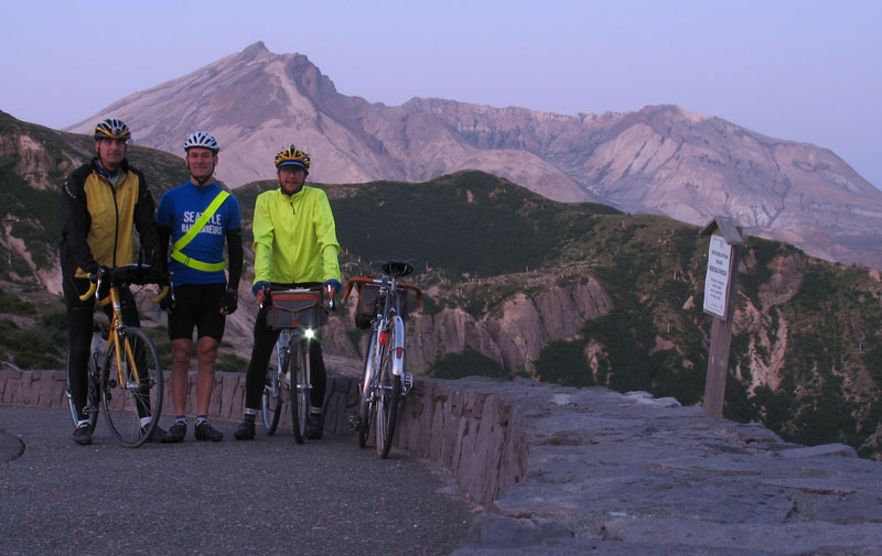
An hour later, we reached Randle, the gateway to Mount St. Helens. We checked out watches – 2:07 a.m. We still were ahead of schedule, but now we faced 52 km of almost relentless uphill. We crossed the old bridge over the Cowlitz River, an almost mystical entry into a different, premieval world. Mark had predicted that we would not see a single moving vehicle from Randle to Windy Ridge, and indeed, after a truck met us on the bridge, it was the last car we were to see for almost four hours. We quickly crossed the valley and started the real climbing. Knowing the road from last year's rides helped us pace ourselves. Even so, my bike's small gear (34-24) was too large in places, and I had to rise out of the saddle. The narrow road winds through the forest, with patches of gravel here and there. Field mice scattered as we approached, and we heard owls in the trees. We each set our own pace on the climb, sometimes within a few feet of each other and sometimes peacefully isolated a few hundred meters away. After a long-ish descent, we entered the blast zone of Mount St. Helens, where the hills get steeper. The previous year's washout had been repaired, but there still were plenty of places where deep ash had washed onto the road, making me wish for tires wider than my 32 mm. We reached the junction with Forest Road 99 sooner than anticipated, perhaps because the different sensations of riding at night made the time pass more quickly. Almost unnoticed by us, twilight now bathed the landscape with a faint light, making the descent from Independence Pass much easier, as we could see the road ahead of our headlights' beams. On the next climb, I almost ran over a porcupine that was resting on the warm pavement and scampered off confusedly as our bikes approached. At 5:16, we reached Windy Ridge and looked upon Mount St. Helens' crater in the pink morning light. A single camping van was parked in the parking lot, but everybody appeared asleep, or already out hiking, so we had this moment to ourselves. |
Sunrise on Windy Ridge/Mt. St. Helens. |
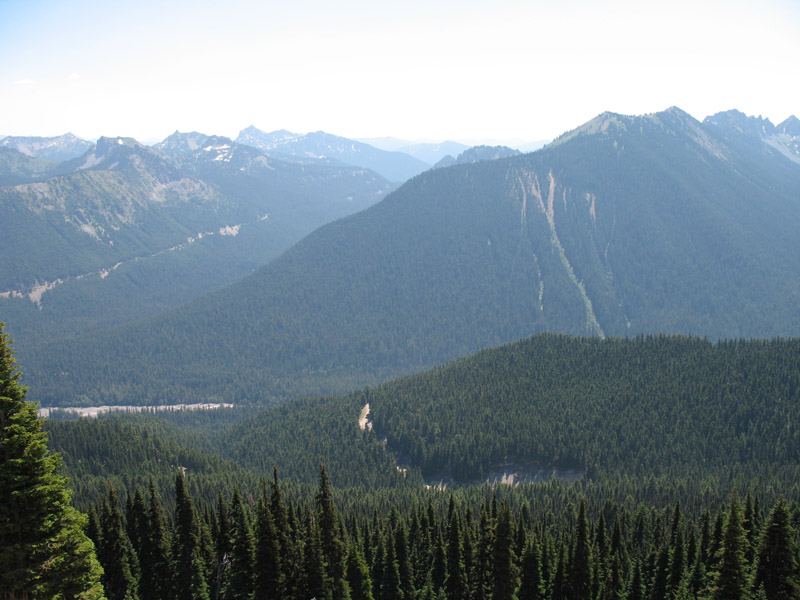
As we turned around, we faced the silhouette of Mount Adams, which stood out sharply against the yellow dawn. Rounding a bend in the road, we suddenly faced Mount Rainier. Far below us were the verdant valleys reclaimed by vegetation after the tremendous volcanic blast and mudslides 29 years ago. Up here, the giant gray tree trunks still bore witness to the cataclysm that within seconds changed this landscape from a lush forest to a barren desert. With a shorter growing season at this elevation, vegetation was taking longer to regrow, and only the undergrowth had filled in. The enjoyable twists and turns of the descent from Independence Pass took our minds off the landscape and focused them on the road ahead. Another little climb, and we reached Bear Meadow, but none of its namesake mammals were in evidence. From there, it was almost all downhill back to the Cowlitz River valley. The roads dipped and turned, and we got into a full aero tuck to maximize our speed – not only to save time, but also because descending faster was more fun. Mark and Ryan pulled off at a campground to refill their bottles, while I recovered a water bottle and four bottles of Ensure meal replacement drink that I had stashed on the way up, inside the guard rail of a bridge. I had left the food there on the way up, a few hours earlier, as much to lighten the bike as to improve its handling on the steep climb. (My Alex Singer was not designed for a heavy handlebar bag.) The sun was shining brightly as we turned onto the farm road in the river valley. The main highway was flatter and smoother, but this road was more enjoyable, and we were confident that we could spare a few minutes to savour this road. We reached Packwood and settled into the cafe for 20 minutes of welcome rest, our first real stop since leaving Seattle 13.5 hours ago. Having made good time since Windy Ridge, we were 50 minutes ahead of schedule. Having covered almost two thirds of the distance, we just had to climb Cayuse Pass and Sunrise, and then return to Seattle on this glorious summer day. |
Mount St. Helens crater in the morning sun. |
Part 2: Packwood - Seattle by Mark Vande Kamp with Ryan Hamilton It was certainly a glorious summer day, but Packwood marked a point where the ride started to become truly challenging. Climbing to Windy Ridge under the stars, seeing the sun rise at the top, and descending in the early-morning sun etched memories that I will never forget, but now the sun was higher in the sky and although I was still optimistic about meeting our time goal, the euphoria was gradually fading. I've ridden the highway between Packwood and the Steven's Canyon Road many times before, but I'm not sure I ever rode in this direction. This morning, I was finding it to be a much more sustained climb than I expected. It wasn't hard enough to keep me from feeling very sleepy for the first time on the ride, but my speedometer told me we weren't making very good time.
|
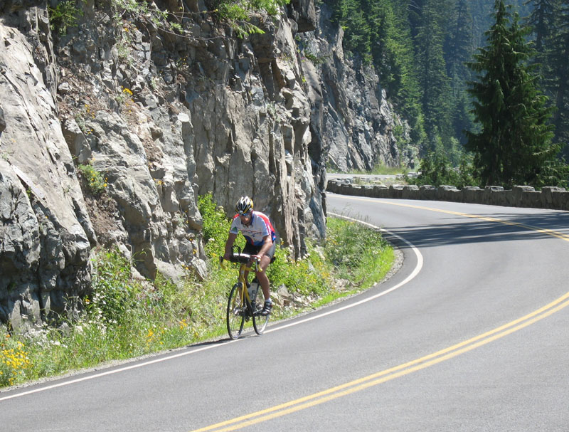
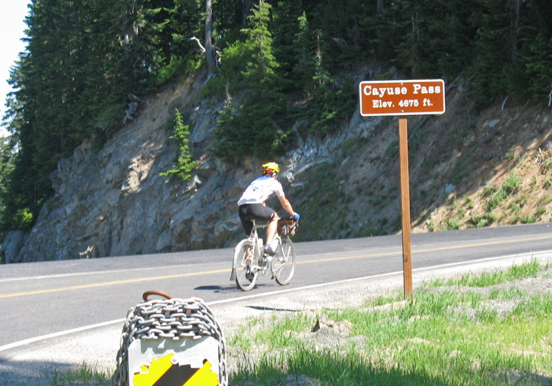
Mark climbs Cayuse Pass near Mt. Ranier. |
| After we passed the junction with Steven's Canyon Road, I was truly on familiar ground. The Cayuse Pass climb is not steep, but it is almost unrelenting. As on some of the earlier climbs, we each set our own pace, Jan ahead, I in the middle, and then Ryan. This was really great for me because I could (selfishly) reason, "As long as I'm ahead or Ryan, I'm not the one responsible for our team's pace." I rode steadily, savoring the shade of the huge old-growth trees, and never felt quite hot enough to dunk my head under any of the small waterfalls that periodically cascaded down the rocky bank on my right. When my sleepiness returned, I stopped at a pull-off and lay down on the cool, shaded blacktop. Ryan caught up quite quickly, re-emphasizing for me how much difference there is between stopping and slowing down. I re-mounted my bike and after a few words with Ryan fell back into my prior rhythm. |
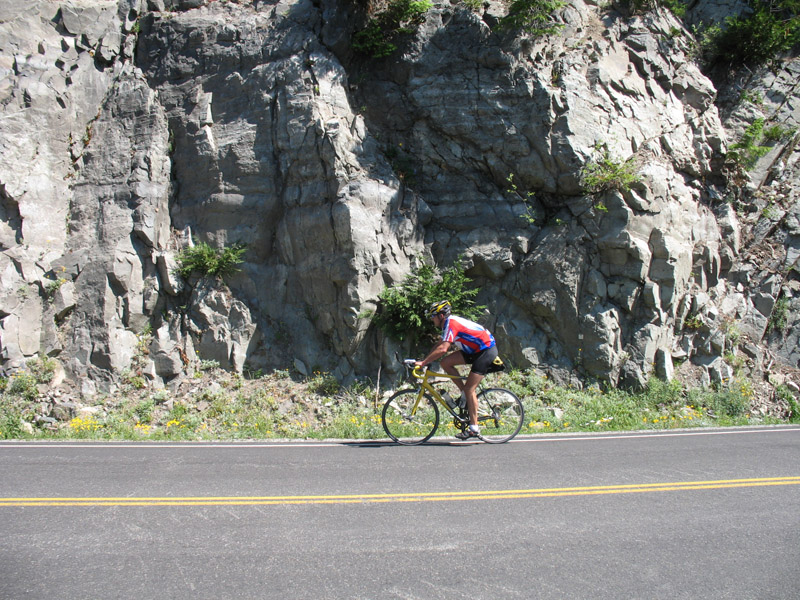
Ryan battles the grade on Cayuse. |
The sign announcing a reduced speed limit is the definitive confirmation that Cayuse Pass is just ahead. As I approach the pass I see Jan preparing to take my photo as I ride in front of the road sign noting the elevation. Whether I'm faster than he expected (unlikely), or his camera is not as accessible as he expected, I end up passing the sign before he's ready, so he asks me to ride back and re-enact the moment. When I see that I can do that without losing more than a foot or two of hard-won altitude, I loop back. I decide not to smile for the camera because I figure the picture should be a more realistic representation of my mood at the time. I ride ahead of Ryan and Jan on the descent to the White River Road, the route to our last climb to Sunrise. At the entrance station I again lay down in the shade. I should have filled up my bottles with cold water, as Ryan did when he arrived, but I thought I had enough for the climb ahead. In retrospect, failing to fill up with plenty of fresh cold water was a mistake. |
Ryan near the pass. |
The crux of the climb to Sunrise is a two-mile long ramp up the side of the ridge with scarce shade and even less wind. Somewhere along that ramp I found myself low on water and decided to take a break and see if Ryan could spare some of his. He arrived and was happy to share a few squirts from his bottle (already lukewarm). When we set off it was obvious that Ryan was feeling no better than I was. I'm surprised at how quickly he drops from sight behind me. |
 |
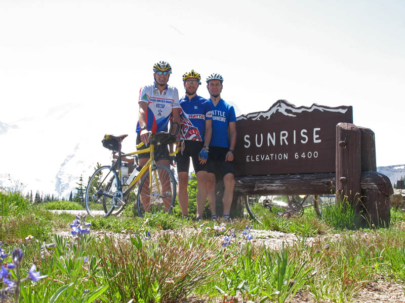
| The road flattens on the last stretch to Sunrise, but I don't really speed up. Riding slowly is torturous, but it's all I can muster. I shift positions as the pain in my feet, butt, shoulders, back, and hands waxes and wanes. When the air moves at all, I can tell the temperature is actually very reasonable, but the sun's rays at 6400 feet feel like hot, stinging needles. I finally reach the Sunrise Lodge, and Jan quickly offers to get me a Coke. I start in on it but I'm not really taking recovery very seriously – I've completely given up on making the 24-hour time limit, and I'm thinking only about bail-out options. Should I make the “call of shame” to my wife once we reach Enumclaw, or find a hotel room there and make an easy ride home tomorrow? |
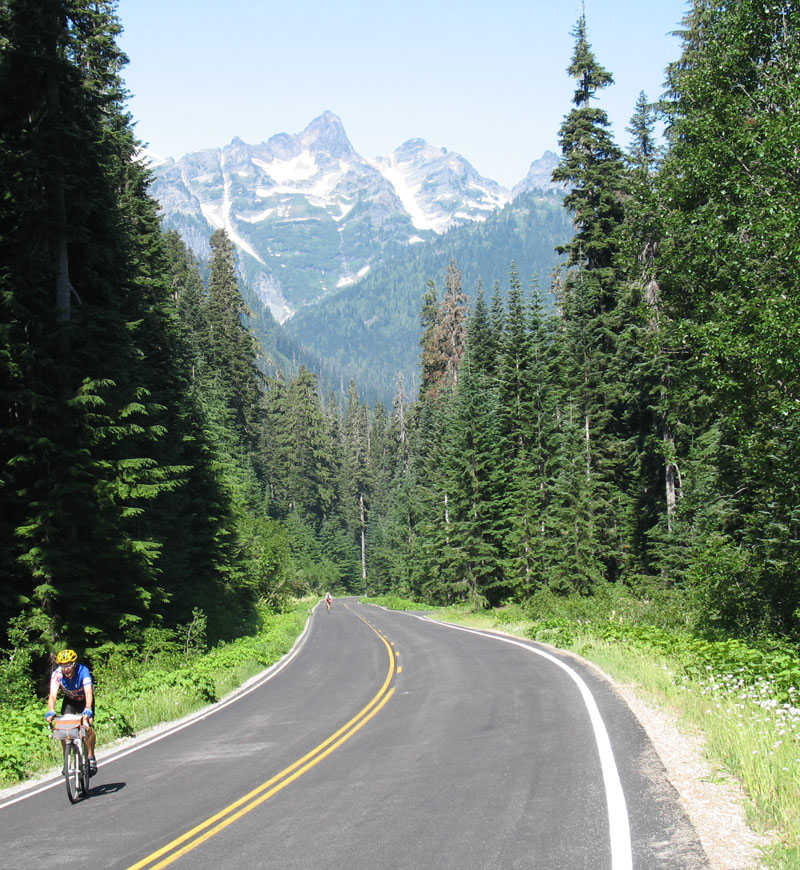
The road to Sunrise, with Mount Rainier in the background. |
I wish I had felt good enough to enjoy the breathtaking views of Mount Rainier and of the ridges and valleys below, and the clear mountain air at Sunrise. The wildflowers were spectacular, with the alpine meadows resplendent in blue lupins, with occasional dashes of red indian paintbrushes. But the reality is that my mind was elsewhere. Ryan adds: My outward appearances were clearly broadcasting my internal condition. I had picked an intelligent gear and pace for the final kilometers to Sunrise—steady, but slow so as to not dig myself into a hole. Mark was pulled off the side for a moment which allowed me a chance to catch up. He was seeking just a little water for the remainder of the climb. No problem, I had a bit to spare. Mark looked me in the eye with mixture of concern and pity. “Are you okay?” he inquired. Hmm, I must really look like crap. “I’ll make it fine, but I’m ready to be there,” I weakly croaked. Finally at the top, I was able to refill water and chug a couple of Mountain Dews. I knew my vitals were flashing yellow—too hot, dehydrated, low electrolytes, low blood sugar. A good solution would have been to take an hour—cool down, drink, pop some e-tabs, and eat something. It seemed somewhat reasonable, however, that these could all be accomplished while flying down the road. Without much urging I was game to get cruising. |
The view back into the valley. |
Jan suggests that we get going. Knowing that there are miles of descending, and eager to just get off my bike, I agree. Ryan's response suggests that he feels similarly. Jan tells us to just stay on his wheel. The ride to Greenwater passes much more quickly than I was expecting. At some point Jan asks: “Can you follow my wheel and maintain this speed?” Ryan and I both think we can, and we have surprisingly recovered to some degree. I'm terribly sleepy. At one point I literally fall asleep for a moment while drafting with my front wheel within a foot of Ryan's rear wheel. I wake up almost instantly, and the adrenaline shot keeps me going for awhile. The sleepiness fades around the time when Ryan and I switch spots behind Jan's lead and the road's descent begins to be broken by rolling up-hills and short flats. We maintain this road position for the remainder of the ride. |
Wildflowers in the meadows near Sunrise. |
Ryan adds: At this point, I was chuckling at a remark Mark had made early in the morning when he and I were filling water bottles at a campground. I had commented that it appeared Jan didn’t ever really need food or water. “I don’t understand how he can eat and drink so little—it’s weird” I said. Mark simply replied “Jan’s a mutant.” As I sat in third position drafting, I thought, “Mutant indeed!” At Sunrise, we had talked of stopping at Greenwater, but Jan asks if we are OK to go on to Enumclaw. I'm actually eager to keep going. My legs have started to feel pretty good. In fact, I think about offering to take a pull, but the next small rise in the road puts that thought to rest, as it's clear that I have no reserve power. |
 |
At the intersection with Mud Mt. Dam road, we do some simple math (made challenging by fatigue) and figure out that we have more than three hours to cover slightly less than 75 km. That doesn't sound out of the question, and I'm a bit surprised to find myself out of bail-out mode and back into the ride. Ryan and I both agree to do our best to hang on Jan's wheel, and he continues his monster pull into substantial headwinds. We make a quick stop for fluids at the Ravensdale store. I feel much worse as soon as I stop pedaling, but I force down some maltodextrin and cold water. Jan dumps some refrigerated water into the helmet vents on top of my head, and the icy shock is the most pure pleasure I've felt in at least twelve hours. Because of the rush-hour time-frame and increasingly dense suburban maze as we approach the metro area, our return route follows the entire length of the Cedar River Trail, including the first unpaved miles. The fresh, deep gravel in the trailhead parking lot and on the first few hundred meters trail make me question this choice, but the trail soon becomes hard packed double track. It's dusty, but easy riding on my 37mm 650b tires. I am not back to where I am really enjoying riding, but the shade is nice and the air seems a bit cooler near the river. We make good time and the trail turns to pavement and begins to spend long stretches right next to a large highway as we near Renton. Finally, we reach the end of the trail under I-405 and return to city streets for our final leg along Lake Washington. Even with an hour to ride the last 16 kilometers, we are well aware the ride isn't over. A wrong turn or two on the confusing streets of Renton, and a major calf cramp that, luckily, quickly releases, make me both anxious and cautious. Jan is finding it hard not to push the pace, but I'm afraid of further cramping if I put forth maximum effort, and Ryan seems to be barely hanging on. At one point Ryan needs to make it clear to Jan: “I’m on the ragged edge, it won’t take much to send me over.” |
 |
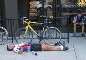
At last, we pull into Starbucks. It's 7:12 and we offer ourselves congratulations all around. Jan has pulled at the front of our paceline for the last 150 km. We go inside to have our cards signed and the same employee who saw us off almost 24 hours ago is on duty. He offers congratulations and ice water. Then the consequences of the ride start to set in. I'm soon throwing up in the garbage can, and Ryan is lying on the ground shaking. Jan makes multiple checks to be sure we aren't in dangerous distress, but there's little he can do except wait for us to get through the worst of things. Within 15 minutes or so, we have both recovered enough to head for home. We stop at Ryan's house and make sure he makes it up the steps to the front of his house, then Jan and I set off, joking about staging our customary sprint in the arboretum. On the last gentle hill to my house, I begin to feel faint and nauseous, but I say a quick good-bye to Jan and make it inside in time to lie down on my living room floor. Unfortunately, I soon find that my stomach has gone on strike, and everything I drank after throwing up at Starbucks comes up again. My wife and I talk things over, and she and my daughter end up taking me to the ER, where I get three liters of IV saline and a series of blood tests assessing my kidney function. I eventually check out fine, but it's not really an ending that's in the best spirit of the Cyclos Montagnards. I'll remember that ending, and hopefully make better choices in the future so I don't re-enact it. But I'll also remember, and cherish, many, many more of the earlier experiences of this Cyclos Montagnards Challenge. |
Ryan (foreground) and Mark (sitting) are finished! |